Our goal is to find changes in local natural environment due to COVID-19. Because huge population relies on farming and logging in Africa, so decrease in human activity can affect the local natural habitat directly. We thought that selecting and offering the right dataset for the local scientists to help them identify any significant changes happening around their local nature would help them continue their research. We searched for different kinds of data, and selected 4 different categories of data from Nasa’s earth dataset. Among the many comparison, we found out satellite images from 2017 March 15th are most clean and visible, so all of the data for comparison with data on March 2020 after COVID-19 is compared with ones on March 15th, 2017.
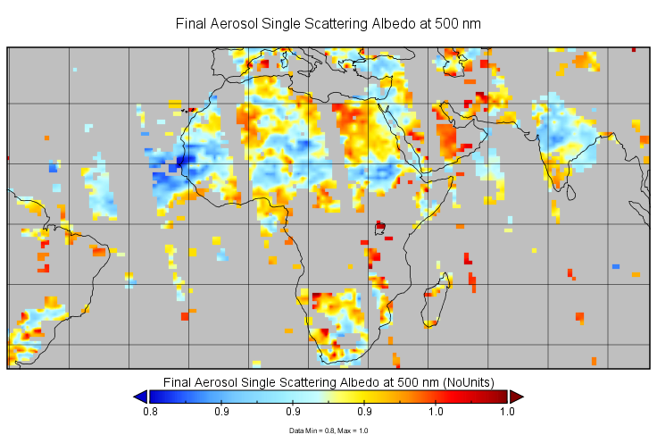
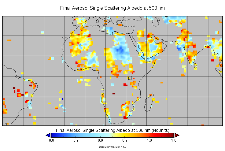
First, we could find a significant decrease in Final Aerosol Single Scattering Albedo at 500nm in 2020 compared to 2017 on the same day. Especially in northern and southern part of Africa, there is no visibility of Aerosol on the satellite images.
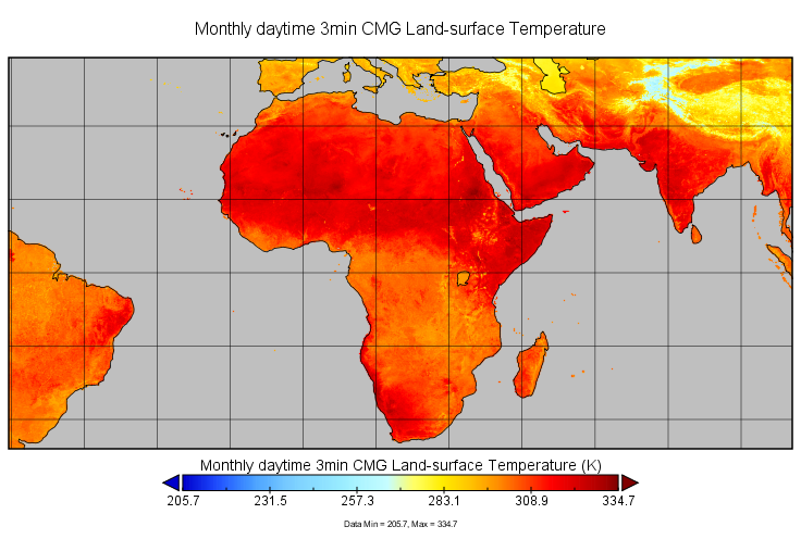
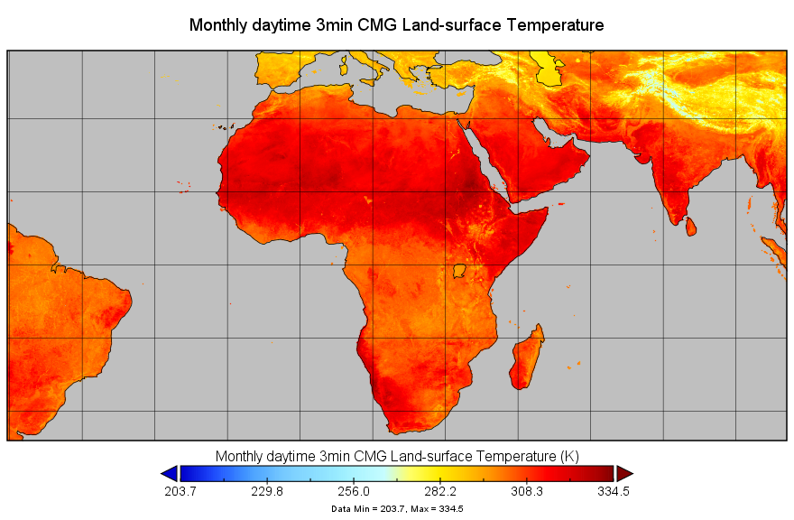
Second, Land-surface Temperature shows a slight change in Africa. Specifically, in Western Africa, we the color gets brighter near Kenya. However, Madagascar’s land temperature is abnormally high compared to 2017, this was due to wildfire in the south.
Third, number of cases of thermal anomaly changes varies among different regions in Africa, but overall numbers of cases decreased as you can see on the graph. The fire radiative power in 2017 is a lot higher overall than 2020. However, in middle Africa, the fire anomaly index is concentrated compared to 2017.

.png)
.png)

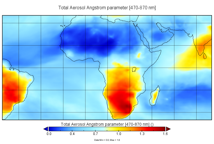
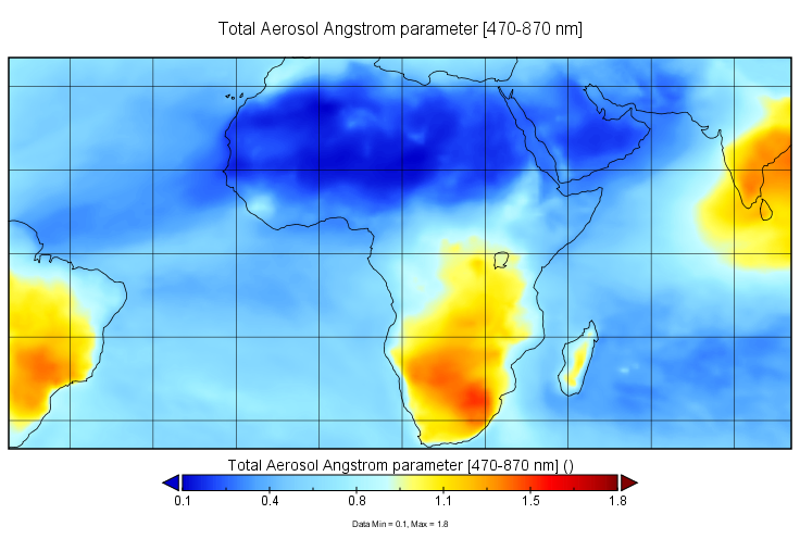
Fourth, total aerosol distribution of higher level of angstrom parameter [470-870nm] is greatly decreased in southern Africa in 2020. It means there are less fine air particle which can be produced from smoke from car or factory in the region.
Fifth, the Global daily 9km Net Ecosystem Exchange(mean) is decreased in 2020 compared to 2017 which means there are more amount of carbon produced by heterotrophic respiration in this year. This can be related to increase in wildlife activity as well as less amount of net primary production as well due to less carbon output in local environment.
/nee_mean_in_SMAP_L4_C_mdl_20170315T000000_Vv4040_001.png)
/nee_mean_in_SMAP_L4_C_mdl_20200315T000000_Vv4040_001.png)
The problem we face with lack of local observatory data can be solved by utilizing satellite data and nasa earth data. Local Scientists can access to these data mentioned above to get near real-time data to keep monitoring possible anomalies and changes in their local environment due to decrease in human activity during COVID-19 pandemic. Not only scientists can benefit from these data, but also citizens can use these easily accessible data to educate themselves around the world.
However, the mere amount of data is too big to be processed without prior knowledge about the topic. Therefore, we propose to build an app that only provides users with data directly related to their chosen topic. As our challenge is about possible changes in natural environment due to COVID-19, we propose our app to include specifically 5 categories which are:
- Final Aerosol Single Scattering Albedo at 500nm
- Land-surface Temperature
- thermal anomaly
- total aerosol distribution of higher level of angstrom parameter [470-870nm]
- Global daily 9km Net Ecosystem Exchange(mean).
Under this category, we use NASA open API and near real-time satellite data to provide users with latest as well as largest dataset. In this way, not only professionals but also citizens with no scientific background can get access to the data and educate themselves. We hope for the better future where everyone can benefit from the readily available data and prepare for unpredictable future especially in times like COVID-19 crisis.